28 March, 2019
Two improvement projects scheduled to strengthen Thanet coastline against flooding
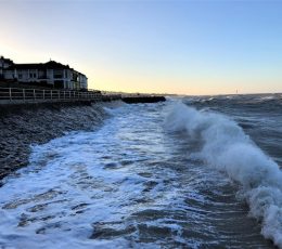
Two coastal projects, led by Thanet District Council, will take place along sections of both the Ramsgate and Margate coastlines this April to improve resilience from the sea.
The first scheme will start in Ramsgate, for approximately 16 weeks, and will focus on improving existing flood defences. Specifically, this involves re-facing to the concrete seawall along Granville Marina and Esplanade and raising the height of the existing groyne. In addition, this scheme will see the installation of a new 80cm high wave wall to deflect water away from Granville Marina. This will raise the flood defences at Granville Marina to a 1 in 200 year level of protection from flooding*. Further work will involve alterations to the highway to improve access.
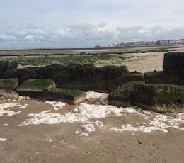
The second project is a refurbishment scheme which will strengthen flood defences between the Westbrook Groyne and Nayland Rock. The work is fully funded by the Environment Agency and will involve the refurbishment of a dilapidated groyne and the stone sea wall. This work is estimated to last for six weeks from 1 April 2019.
Mike Humber, Head of Maritime and Technical Services at Thanet Council said: “These schemes are vital to preserve and sustain the sea walls on our award-winning coastline. Some of our coastal defences are quite old and it’s important that we maintain or where necessary, carry out major works to ensure they are able to meet standards for predicted adverse weather in the future.
“Despite causing a small amount of disruption, these schemes will bring significant benefits to the local area. Maintaining these flood defences is an important part of ensuring we are doing all we can to protect our residents, local businesses, and visitors from the potential devastating impacts of flooding.”
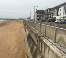
Both schemes have been developed by the Technical Services team at Thanet District Council. This team is responsible for coastal management along 16 miles of Thanet’s 19 mile coastline. Thanet has 11 miles of concrete sea walls which protect the land behind from erosion or flooding by the sea. The team undertakes continuous maintenance of Thanet’s sea walls and promenades and carries out programmed inspections to monitor its condition and identify necessary repair work.
Predominantly funded by the Environment Agency, the estimated cost of the work in Ramsgate is £900,000 and will protect this stretch of coastline for at least 50 years. The Westbrook to Nayland Rock scheme in Margate (£180,000) is fully funded by the Environment Agency.
Mark Douch, Flood and Coastal-Erosion Manager for the Environment Agency in Kent, said: “Helping protect communities like east Kent from flood-risk is a partnership. The Environment Agency works with local authorities like Thanet to reduce the chances of flooding to residential and business properties locally, which shows the benefit of agencies handling projects together.
“Part of £2.6bn the Environment Agency is spending on flood and coastal-erosion projects around England, the £1m investment towards the flood defences at Ramsgate and Margate compliments the £5.3m spent on the award winning scheme in Margate in 2012.
“Join the 1.4 million properties already signed up to our flood-forecasting service. Search online for “sign-up for flood warnings” to do that and be better-prepared if the worst happens.”
——————–
*According to Risk of Flooding From Rivers and the Sea (RoFRaS)
Risk of Flooding from Rivers and the Sea data provides a broad brush assessment of the likelihood of flooding. It calculates the likelihood of flooding to areas of land within the flood plain of an extreme event (taking into account flood defences). The data is divided into 4 probability bands:
-
Less than 1 in 1000 (0.1%) chance in any given year Very Low
-
Less than 1 in 100 (1%) but greater than or equal to 1 in 1000 (0.1%) chance in any given year Low
-
Less than 1 in 30 (3.3%) but greater than or equal to 1 in 100 (1%) chance in any given year Medium
-
Greater than or equal to 1 in 30 (3.3%) chance in any given year High
RoFRaS takes into account the location, type and condition of local flood defences, and shows the probability that land, not individual properties will flood.
Share this story
Newsroom
See all
REGENERATION & DEVELOPMENT
Historic Theatre Royal Margate set to reopen in 2027 after major plans approved
Thanet District Council’s planning committee has approved plans for the reopening of the Theatre Royal Margate. This decision marks a major milestone for the second oldest theatre in the United Kingdom, which has been closed since April 2022. The approved plans will breathe new life into the Grade II* listed building. The project will focus […]
20 Jul 2026

COMMUNITY
Community Day comes to Broadstairs this summer
Thanet District Council is inviting people to a free day of family fun, wellbeing and safety this summer. The Community Day will happen at the Memorial Recreation Ground in Broadstairs on Wednesday 29 July 2026. Open to the public from 11am to 3pm, the event brings together two popular community initiatives: the Thanet Games and […]
16 Jul 2026

COUNCIL AND DEMOCRACY
Kent and Medway to be served by four unitary councils from 1 April 2028
In a statement to Parliament earlier today (Thursday 16 July 2026), the Secretary of State has announced that Kent and Medway will be served by four unitary councils from 1 April 2028.
16 Jul 2026