Update 13 January 2020
Westgate Town Council submitted a draft neighbourhood plan to the Council for screening purposes for Strategic Environmental Assessment and Habitats Regulations Assessments. The Council prepared a Screening Report (click to view) and consulted the relevant Statutory Consultees (Natural England, the Environment Agency, Historic England) for a 5 week period in October/November 2019. Comments were received confirming the Council conclusion that the draft Neighbourhood Plan does not need a Strategic Environmental Assessment or Habitats Regulations Assessment.
Update 13 November 2019
Following the recent public consultation, the Council designated the Monkton Neighbourhood Plan Area on 12th November 2019. The neighbourhood plan area can be viewed in the Monkton Neighbourhood Plan section below.
The Council proposed modifications to the Broadstairs & St Peters neighbourhood plan which it considered, together with the recommendations made by the Examiner in his report, will enable the neighbourhood plan to proceed to referendum.
Two of the designations of Local Green Spaces proposed in the neighbourhood plan are considered to be contrary to national policy and policies in the emerging Thanet Local Plan. The Council proposed modifications to the neighbourhood plan and carried out a six week consultation on these modifications. The consultation ran from Friday 20th September – 5pm Friday 1st November 2019.
The results of the consultation will be reported to members in due course.
Update 1 April 2019
- Examiner procedural Matters and questions Broadstairs St Peter’s NP 28 March 2019
- Response to Examiners Questions – 28 March 2019
- Broadstairs & St Peter’s Neighbourhood Plan – Local Plan Housing sites
Community-led planning
The Localism Act introduces the following new types of community-led planning:
- Neighbourhood Development Plan – sets out policies on the development and use of land and forms part of the local plan
- Neighbourhood Development Order – grants planning permission for a specific location
- Community Right to Build Order – provides for community led site development
Neighbourhood Development Plans
These will set out a vision for an area and planning policies for the use and development of land. The Councils policies in the Local Plan will set the context within which neighbourhood plans will sit. Neighbourhood plans will be about local rather than strategic issues, for example, where new shops, offices or homes should go or how a development site allocated in the Local Plan should come forward. Neighbourhood plans need to be compatible with national policies and the policies in the Council’s local plan. They should be focused on guiding development and cannot be used to block development. If a neighbourhood plan is adopted it will become a statutory plan and be used in making decisions on planning applications.
As an alternative to Neighbourhood Plans, Business Neighbourhood Plans can be developed in areas which are dominated by business interests.
Neighbourhood Development Orders
These can grant planning permission for specified developments in a neighbourhood area, for example, certain types of household extensions, shop fronts, ‘green energy’ proposals. Where there is a neighbourhood development order in place there would be no need to apply to the Council for planning permission for the development it covers.
Community Right to Build Orders
Appropriately constituted community groups will be able to identify land for new, small scale development such as new homes, shops or other community facilities.
Preparing a Neighbourhood Plan
Please click here for information on Preparing a Neighbourhood Plan
Local Planning Authority Support
The Council will provide support and advice to the organisation preparing the Neighbourhood Plan, but it is up to the Parish/Town Council or Neighbourhood Forum to prepare the Neighbourhood Plan.
The Council, in conjunction with Planning Aid England, organised a Neighbourhood Planning Event in Summer 2012, to which a number of Parish and Town Councillors attended.
If you are interested in finding out more, or are thinking about developing a Neighbourhood Plan, please contact the Strategic Planning Team.
Further Guidance
Guidance and advice is also available from the government and other bodies from the following links:
Department for Communities and Local Government
Planning Advisory Service Guidance
Locality. Communities Ambitious for change
The Birchington Parish council Neighbourhood Plan Area application was designated on 8th December 2016.
Within Planning Policy – Neighbourhood and community-led planning – Current Neighbourhood Planning in Thanet:
Under the Localism Act 2011, local communities can produce Neighbourhood Plans, setting out policies on the development and use of land in their area. If the plans are adopted by the District Council they will have the same weight as other Development Plan documents for the District.
A Neighbourhood Plan is a community-led framework for guiding the future development and growth of an area. It may contain vision, aims, planning policies, proposals for improving the area or providing new facilities, or allocation of key sites for specific kinds of development. It may deal with a wide range of issues (like housing, employment, heritage and transport) or it may focus on one or two issues that are of particular importance in a local area.
First stage
The first stage in the neighbourhood planning process is for a Town or Parish Council, or a proposed Neighbourhood Forum, to apply to Thanet District Council for the designation of the area they consider would be appropriate to be covered by a neighbourhood plan.
Birchington Parish Council applied to Thanet District Council to designate a Birchington Neighbourhood Plan Area (under Regulation 5 of the Neighbourhood Planning (General) and Development Management Procedure (Amendment) Regulations 2016)
A complete and valid application to designate the whole of the area of the town council was received by Thanet District Council on 8 December 2016. The Local Planning Authority must therefore exercise their powers under section 61G of the 1990 Act to designate the specified area as a neighbourhood area.
The Council is required to publicise the following information under Regulation 7 of the Neighbourhood Planning (General) Regulations 2012:
Birchington Neighbourhood Plan Area
Map identifying area:
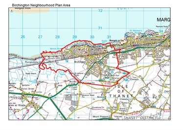
Name of body who applied for designation: Birchington Parish Council
If you would like any more information on what neighbourhood planning is all about please contact us below.
PermalinkFirst stage
The first stage in the neighbourhood planning process is for a Town or Parish Council, or a proposed Neighbourhood Forum, to apply to Thanet District Council for the designation of the area they consider would be appropriate to be covered by a neighbourhood plan.
The Council consulted on an application from Ramsgate Town Council to designate a neighbourhood area from 13 October – 21 November 2014. 72 responses were received and were generally supportive of the proposed area.
The proposed neighbourhood plan area was designated by Cabinet at a meeting on 18 June 2015.
The Council is required to publicise the following information under Regulation 7 of the Neighbourhood Planning (General) Regulations 2012:
Name of the area: Ramsgate Neighbourhood Plan Area
Map identifying area:
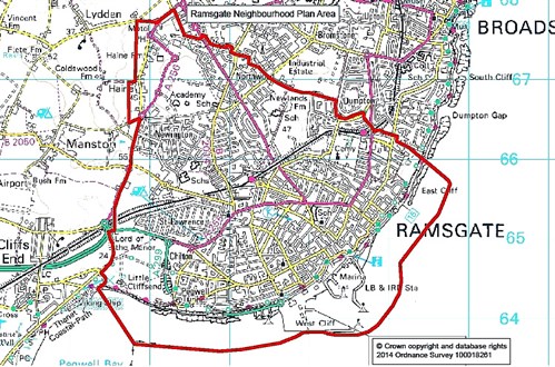
Name of body who applied for designation: Ramsgate Town Council
If you would like any more information on what neighbourhood planning is all about please contact us below.
PermalinkFirst stage
The first stage in the neighbourhood planning process is for a Town or Parish Council, or a proposed Neighbourhood Forum, to apply to Thanet District Council for the designation of the area they consider would be appropriate to be covered by a neighbourhood plan.
The Council consulted on an application from a proposed Margate neighbourhood forum to designate a neighbourhood area from 6th January – 14th February 2014. 33 responses were received and were generally supportive of the proposed area.
The proposed neighbourhood plan area was designated by Cabinet at a meeting on 1st May 2014.
The Council is required to publicise the following information under Regulation 7 of the Neighbourhood Planning (General) Regulations 2012:
Margate Neighbourhood Plan Area
Map identifying area:
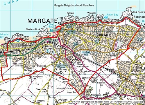
Name of body who applied for designation: Proposed Margate Neighbourhood Forum
Second stage
In areas that are not within the jurisdiction of a town or parish council, a Neighbourhood Forum must be designated by the Council in order to produce a Neighbourhood Plan.
The proposed Margate Neighbourhood Plan Forum have applied to the Council for formal designation as a Neighbourhood Forum. The Council consulted on this application from 6th January-14th February 2014. 20 responses were received and were generally supportive of the proposed neighbourhood forum.
The proposed Margate neighbourhood forum was designated by Cabinet at a meeting on 1st May 2014.
The Council is required to publicise the following information under Regulation 10 of the Neighbourhood Planning (General) Regulations 2012:
Name of neighbourhood forum: Margate Neighbourhood Forum
The Margate Neighbourhood Forum Constitution
PermalinkBroadstairs & St.Peters Town Council have submitted their draft Neighbourhood Plan (which includes a map identifying the area to which the plan relates) to the Local Planning Authority (Thanet District Council), together with a Consultation Statement and “basic conditions” statement.
Broadstairs & St Peter’s Neighbourhood Plan Area
Map identifying area:
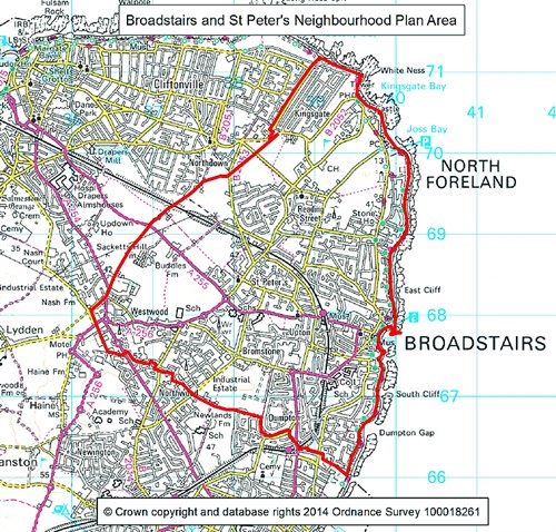
Name of body who applied for designation: Broadstairs & St Peter’s Town Council
If you would like any more information on what neighbourhood planning is all about please contact us below.
PermalinkUnder the Localism Act 2011, local communities can produce Neighbourhood Plans, setting out policies on the development and use of land in their area. If the plans are adopted by the District Council they will have the same weight as other Development Plan documents for the District.
A Neighbourhood Plan is a community-led framework for guiding the future development and growth of an area. It may contain vision, aims, planning policies, proposals for improving the area or providing new facilities, or allocation of key sites for specific kinds of development. It may deal with a wide range of issues (like housing, employment, heritage and transport) or it may focus on one or two issues that are of particular importance in a local area.
First stage
The first stage in the neighbourhood planning process is for a Town or Parish Council, or a proposed Neighbourhood Forum, to apply to Thanet District Council for the designation of the area they consider would be appropriate to be covered by a neighbourhood plan.
Westgate-on-Sea Town Council applied to Thanet District Council to designate a Westgate-on-Sea Neighbourhood Plan Area (under Regulation 5 of the Neighbourhood Planning (General) and Development Management Procedure (Amendment) Regulations 2016)
A complete and valid application to designate the whole of the area of the town council was received by Thanet District Council on 20th October 2016. As the proposal is for the whole parish council area, the Local Planning Authority must exercise their powers under section 61G of the 1990 Act to designate the specified area as a neighbourhood plan area.
The Council is required to publicise the following information under Regulation 7 of the Neighbourhood Planning (General) Regulations 2012:
Westgate-on-Sea Neighbourhood Plan Area
Map identifying area:
Name of body who applied for designation: Westgate-on-Sea Town Council
If you would like any more information on what neighbourhood planning is all about please contact us below.
PermalinkFirst stage
The first stage in the neighbourhood planning process is for a Town or Parish Council, or a proposed Neighbourhood Forum, to apply to Thanet District Council for the designation of the area they consider would be appropriate to be covered by a neighbourhood plan.
The Council consulted on an application from Cliffsend parish council to designate a neighbourhood area from 6th January – 14th February 2014. 22 responses were received and were generally supportive of the proposed area.
The proposed neighbourhood plan area was designated by Cabinet at a meeting on 1st May 2014.
The Council is required to publicise the following information under Regulation 7 of the Neighbourhood Planning (General) Regulations 2012:
Cliffsend Neighbourhood Plan Area
Map identifying area:
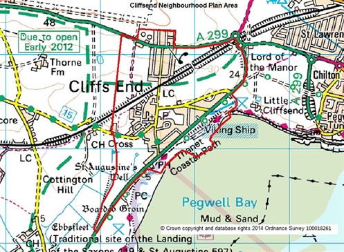
Name of body who applied for designation: Cliffsend Parish Council
If you would like any more information on what neighbourhood planning is all about please contact us below.
PermalinkThe Monkton Neighbourhood Plan Area was designated on 12th November 2019.
Under the Localism Act 2011, local communities can produce Neighbourhood Plans, setting out policies on the development and use of land in their area. If the plans are adopted by the District Council they will have the same weight as other Development Plan documents for the District.
A Neighbourhood Plan is a community-led framework for guiding the future development and growth of an area. It may contain vision, aims, planning policies, proposals for improving the area or providing new facilities, or allocation of key sites for specific kinds of development. It may deal with a wide range of issues (like housing, employment, heritage and transport) or it may focus on one or two issues that are of particular importance in a local area.
First stage
The first stage in the neighbourhood planning process is for a Town or Parish Council, or a proposed Neighbourhood Forum, to apply to Thanet District Council for the designation of the area they consider would be appropriate to be covered by a neighbourhood plan.
Monkton Parish Council applied to Thanet District Council to designate a Monkton Neighbourhood Plan Area (under Regulation 5 of the Neighbourhood Planning (General) and Development Management Procedure (Amendment) Regulations 2016)
A complete and valid application to designate the whole of the area of the parish council was received by Thanet District Council and the Council consulted on the application from 20th September – 1st November 2019. The Council must therefore exercise their powers under section 61G of the 1990 Act to designate the specified area as a neighbourhood area.
The Council is required to publicise the following information under Regulation 7 of the Neighbourhood Planning (General) Regulations 2012:
Monkton Neighbourhood Plan Area
Map identifying area:
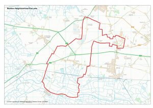
Name of body who applied for designation: Monkton Parish Council
Permalink